
In case you thought “flat top” was just a military style haircut, think bigger and higher—like 235,214 acres bigger and 10,000 feet higher. The Flat Tops Wilderness Area is among Colorado’s top three largest wilderness reserves—a landscape rich with every imaginable type of Rocky Mountain terrain, including towering peaks, pine trees, volcanic cliffs, alpine tundra, glistening lakes, crashing rivers, and, yes, picturesque bluffs with smooth, flat plateaus.
In many ways, the Flat Tops represent the birth of America’s very concept of wilderness. When U.S. Forest Service representative Arthur Carhart initially scouted the area in 1919, he found it so stunning that he recommended that it remain undeveloped. It thus became the first expanse of public land deemed “wilderness.” It wasn’t until 1932 that the U.S. Forest Service officially designated the land, about 48,000 acres of it. Then, in 1964, following the passage of the Wilderness Act, the Forest Service recommended that the protected land mass triple in size. Certain interest groups were not happy with this proposal, as they wanted to develop the land for oil and timber extraction. Happily, conservationists prevailed. In 1975, President Gerald Ford signed the law to designate 235,214 acres of land the protected Flat Tops Wilderness.
This made it possible for the Flat Tops, with its 110 lakes and ponds, 100 miles of fishable streams and more than 160 miles of trail, to be relished by hikers, backpackers, campers, and anglers. Interested in seeing the massive wilderness for yourself? Here are some of the top options for visiting this unique part of Colorado.
Best Loop Hike

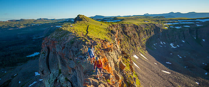
The Devil’s Causeway/Chinese Wall/Bear River hike features a stunning wall of jagged basalt rock formations that are exactly when you’d envision if Mother Nature gave the mountains a flat-top haircut. This hike begins at the parking lot on the north side of Stillwater Reservoir, and it will take you through wildflower-strewn meadows, passed Little Causeway Lake, and across the Devil’s Causeway itself.
Even if you’re not afraid of heights, your knees may start trembling along this ridge. Many hikers resort to crawling on hands and knees to navigate the narrow trail (only three feet wide in places) along the ridgeline that rises to nearly 12,000 feet along the rocks—with sheer vertical drops on either side. Don’t forget to look around, though. The panoramic views are other-worldly. Many hikers turn back the way they came when the (East Fork) trail ends at the Chinese Wall Trail, the out-and-back of which measures 6 miles with about 1,550 feet of climbing. For the 10.5-mile loop option, turn left on the Chinese Wall Trail, hike about 2.4 miles to the Bear River Trail, where you’ll take another left and continue for about 4 miles back to Stillwater Reservoir.
Best Camping
The majority of campgrounds and sites in the Flat Tops Wilderness are located near the area’s many lakes and ponds (don’t forget, there are 110 of them). You’ll find numerous small campgrounds with water and restrooms in the heart of the Flat Tops near Trappers Lake, two of which are Shepherds Rim, offering a circle of 15 well-spaced sites, and Trapline, with 13 sites and picnic tables. The much larger Bear Lake Campground near the town of Yampa features 43 sites and easy access to the fishing pier, reservoir, and recreation area. While the majority of spacious, RV-sized sites are situated in the dense, shaded pine trees, there are many sites with fire rings outside of the woods with views of Bear Lake and surrounding peaks.
Best Backpacking

The Wall Lake/Trappers Lake route is an excellent option for those looking for a longer adventure. Beginning at Trappers Lake, the very spot where Arthur Carhart originally fell in love with the Flat Tops nearly 100 years ago, this 23-mile loop can be done in either direction and makes for a comfortable two- to three-day backpacking adventure.
To get the steepest portion of the route out of the way early, start at the Wall Lake Trailhead. After climbing gently through a pine forest that is in the process of recovering from the 2002 Big Fish Fire, you enter a canyon that switches back steeply and accounts for a significant chunk of the loop’s total 3,700 feet of elevation gain. Along the way, you get beautiful glimpses of Trappers Lake becoming smaller in the distance.
Stay on the Wall Lake Trail at the Oyster Lake Junction on the canyon’s plateau as it crosses a streambed trail that leads to Star Lake (which is a lovely side excursion or lunch spot). You will see Trappers Peak in the distance: Keep it on your right and the valley to your left as you navigate the jagged trail along the canyon’s cliff tops. The woods and meadows surrounding the pristine alpine waters of Wall Lake make for a wonderful place to pitch a tent. From Wall Lake, the trail climbs over a saddle, through a valley of meadows, tundra, and forests until it connects to the Trappers Lake Trail. This trail takes you on a gradual descent with stunning views of the surrounding peaks and Trappers Lake far below. The point where the trail crosses with Island Lakes Trail makes for another peaceful camping spot in the midst of a series of lakes.
Flat Top Must-Sees
There is no shortage of jaw-dropping scenery wherever you are in the Flat Tops, but there are a few landmarks that you should make a point to see.
Trapper’s Peak
If a solitary mountain were to be the poster child of the Flat Tops, Trapper’s would do just fine. The majestic, looming plateau can be seen from numerous vantage points, but among the best is looking southwest of Wall Lake, a gorgeous sight unto itself.
Devil’s Causeway
Even if you don’t venture to the top or cross the narrow, knee-knocking ridgeline of the Devil’s Causeway, catching sight of the craggy, monolithic band of volcanic rock is an opportunity you should not pass up. Best views are from Little Causeway Lake.
Finger Rock
This oddly shaped tower resembles not just one, but at least an entire hand (or two) of fingers reaching into the air. It can be viewed on the east side of Lincoln St. (Highway 131) about 2.5 miles south of Yampa.
Sleepy Cat Peak
Compared to the sea of table-shaped peaks that span before you, this mountain standing alone at the northwestern corner of the wilderness area will catch your eye. It looks just as you’d expect from a distance—like a lounging feline. It can be seen to the east from the town of Meeker, but best views are from trails in the Cedar Mountains.
Written by RootsRated Media for Steamboat Springs Chamber.
Featured image provided by RubyWhatever